
Two routes lead from Sheridan, Wyoming to Red Lodge, Montana.
The quicker is to take 90 north into Montana, till you get to Hardin. At Hardin, you make a hard left and head into Billings, born as a railroad town in 1882, and grown up to be the state’s largest city. From Billings you slide southwest on the map into Red Lodge.
That first section through Hardin roughly follows the course of the Little Bighorn, a river that would be just another inconspicuous watercourse had it not been for a famous battle that occurred along its bank, about 71 miles north of Sheridan.
The clash between five companies of the U.S. 7th Cavalry, led by Lieutenant-Colonel, George Armstrong Custer, and a superior force of Lakota, Northern Cheyenne, and Arapaho, is one of the most famous battles in American History. At the end of an estimated two hour long battle, Custer and his entire command were killed. Custer’s body was found on a hillock that was christened, Last Stand Hill. A monument to the 7th Cavalry sits atop the hill.
My original idea, before we left home, was to take this route and stop at the Little Bighorn Battlefield National Monument. I’ve a long standing interest in military history and the Little Bighorn had been one of those bucket list places.
Having read two books on the battle itself, along with Custer’s own memoir, My Life on the Plains, I’d already known Custer to be one of the most notorious characters in the long running drama of the Indian Wars.
Custer is a study in conflict. He attended West Point where he gained a reputation for being an insubordinate troublemaker who would eventually graduate 34th in a class of 34. Custer was a braggadocios, egotist; a self-promoter who was known for designing his own flamboyant uniforms.
In 1868, after having served a ten month punishment for desertion and mistreatment of soldiers, Custer revived his military career by leading an early morning attack on a band of peaceful Cheyenne near the Washita River in Oklahoma that resulted in the slaughter of 103 Cheyenne, including a number of women and children.
Ever since the famous battle at the Little Bighorn in 1876, Custer has been alternately cast as either a racist incompetent, whose hubris led to the massacre of 268 U.S. Troopers, or a man miscast by history. Custer’s reputation has pin balled between misunderstood hero, narcissistic villain, and tactical blunderer.
The night before we left Custer, South Dakota for Sheridan, I’d decided to take the other route to Red Lodge.
The time that we spent in South Dakota had me weary of paeans to Custer and the U.S. Cavalry; the names of places, streets, towns, schools and monuments that commemorate Custer, his officers and a genocidal war.
That two towns along 90, near the battlefield and located on the Crow Reservation are named Garryowen after the title of the 7th Cavalry’s regimental song, and Benteen after one of Custer’s officers seems to add chauvinist insult to injury.
The other route to Red Lodge heads west until the town of Greybull, Wyoming and then swings northwest towards Red Lodge. This route takes in a section of the Bighorn Scenic Byway.
At the Wyoming-Montana state line we planned to take a short detour into the Pryor Wild Horse Range, a place that I’d wanted to visit six years ago but had to cancel due to bad weather.
Done with touring The King Saddlery on Main Street I stop to fill the tank before we leave Sheridan.
There’s plenty of gas in the tank but ever since the Mojave Desert a few thousand miles ago I’ve been in the habit of not letting the tank get below halfway. This from someone who often runs the tank down to fumes back home in the San Francisco Bay Area.
The price of gas is starting to creep back up here in Wyoming. When we left the Bay Area gas was over $3.00 a gallon. One of the things we enjoyed about Texas was gas at $2.55. Here in Sheridan it’s $2.75, and I imagine the locals consider that to be a highway robbery instigated by Joe Biden.
We’re on Highway 90 headed northwest for 20 miles to Ranchester where we veer west onto Highway 14. It’s a fitting name for a town in this area as we’ve been passing ranch after ranch.

The Sheridan Valley
Ranchester is another one of those tiny pinheads on the map, a brief break in the expanse of Wyoming, before Highway14 rises into the Bighorn Mountains. Ranchester is a jump off for hunters aiming for fall game in the mountains.
There’s almost a formula to these little towns. We pass the essentials; a bank, a lumber yard/hardware store, the grocer, the insurance man, the bean counter, the mechanic and a handful of churches.
We pass the Western Motel, the typical motor court, followed by a coffee kiosk, The Dry Bean Coffee Shed. Looking for something a little stiffer? There’s The Silver Spur Lounge or The Wyoming Buckshot Saloon.
Don’t let the name of the latter mislead you. It’s no dive, a family place with the standard pub food menu; nachos, wings and an array of burger options, one of them, a dubious sounding concoction of hamburger smothered in Thai peanut butter and jalapeño jelly.
To start off the evening, a Basket-O-Balls, better known as rocky mountain oysters. Rocky mountain oysters is a euphemism, a cutesy name for bull testicles, a dish that should never be described in veiled terms. If you’re serving up a plate of nads you need to be straight up honest.
“Mmmm, this is pretty good. What exactly are rocky mountain oysters?”
“Bull’s balls.”
“O-kay. You know, I’m starting to feel a little full. You can have the rest. Uh waitress, a double shot of bourbon please?”
Along the banks of the nearby Tongue River, is the Connor Battlefield Historic Site, where in 1865, 200 U.S. soldiers under the command of General Patrick Connor, attacked an Arapaho village, killing up to 63 villagers including women and children. It marks one of Wyoming’s more than two score sites of battles and skirmishes fought during the dirty business of the mid 19th century.
Ranchester has been home to the Wyoming Wife Carrying Championship, an athletic contest in which you carry, according to the website, “your spouse, significant other, or friend through a challenging obstacle course.”
At first blush I thought it a tad sexist but from what I could gather it’s perfectly within the rules for the wife to carry the husband, though why she would want to do that is a mystery. Seems to me that wives spend much of their married lives carrying their husbands.
Just beyond Ranchester we pass through the even smaller town of Dayton before the road rises up in a string of switchbacks into the Bighorn Range. A glance back reveals the emerald green panorama of the Sheridan valley. The highway climbs at over a 10 percent grade in some places until we get to the Antelope Butte Mountain Recreation Area.

Sheridan Valley as viewed from the Bighorn Range

Sheridan Valley as viewed from the Bighorn Range
When we left Sheridan and the valley, the temperature was already in the 80’s (F). At the summit it’s a refreshing and relieving 55.
What goes up…
Plunges down.
The road descends, in some places steeply, into Shell Canyon. Locked between looming limestone and granite walls, Shell Canyon is named for the fossil shells that can be found in the area.
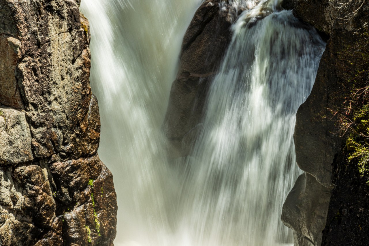
The Shell Falls interpretive site, 26 miles from Greybull is a refreshing break. From the parking lot you can’t see the falls but you can hear it. We take the trails that overlook the canyon, Shell Creek and 120 foot Shell Falls. The temperature is in the low 90’s (F) but just looking at the waterfall brings on a welcome sense of refreshment. An occasional breeze blown mist doesn’t hurt either.

Shell Falls

Shell Falls

Shell Creek
Back on Highway 14 we pass Shell, which barely qualifies as a town. In 2010 the population was 83; 67 men and 16 women.
A wooden building, Dirty Annie’s Gift Shop and Restaurant, complete with a wooden boardwalk was the big deal for a time. It’s closed now. Maybe Annie got sick of all the attention, pulled up stakes and left.
A venerable old building, The Old Shell Store is home to a restaurant and taphouse. The nearby Fossil Rock Tavern lasted just six years before falling victim to COVID. The Fossil Rock’s Facebook page contains the epitaph.
April 19,2021
Dear FOSSIL ROCK FRIENDS, it is time to say what I have been dreading for two years: THE FOSSIL ROCK TAVERN will close for good this Saturday,. April 24. In order for a proper closing, I am calling on all my customers to join us Saturday after 1:00 pm for an open house/say good-bye. Drinks are on the house cuz we need to clean out the beer cooler and liquor cabinet and you all are the ones I want to share my last day at the tavern with. So, please come and join us to celebrate the near 6 years I was able to serve you all. This time was one of the highlights of my life and I hate to see it come to an end. It never could have happened without you all. Ty and I will be leaving Shell by mid-May.
The owner, Verna, must have seen the end nearing last November.
Greetings Fossil Rock Friends! It has been a super long time since I have posted anything; been going through hell & got held up there. Not a pleasant place, haha. Due to my ongoing health issues & the covid-19 issue, I have made the unhappy decision to close the tavern for the winter season.
I guess that Cora and I missed Verna by a little less than a month.
She must be, like a former coworker of mine used to say, “a decent human being.” She apparently turned out the “best burgers” and “amazing pizza.”
“What a great spirit Verna is bringing to Shell. She has been hosting everyone from cowboys to grannies,” wrote one commenter.
Unfortunately, spirit and amazing pizza can’t always feed the bank account, especially during a pandemic.
Wherever Verna is, I wish her well.
Below, views of Shell Canyon


Copmans Tomb, a massive dolomite and limestone promontory, named after Wolfgang Robert Copman,

At Greybull, down in the Bighorn Basin it’s a blistering 97 degrees (F). I’d like to stop and see the town but the heat evaporates the energy right out of you. I’m half falling asleep behind the wheel and Cora wants to find a bathroom.
At the far edge of town is an A&W Drive-In that looks as if it hasn’t changed since 1960. There’s even a carhop, though this carhop isn’t like the ones I recall from my teenage years when we stopped at A&W for Coney Dogs, and a root beer float in a frosted mug. Those carhops were high school girls. I had a major crush on a particular girl named Debbi (yes, with an “I” and no “e”).
Our Greybull carhop is a blonde woman, flirting with the onset of middle age, working solo, and definitely earning her tips today.
It’s relaxed, shady, welcoming and a journey back to pleasant memories.
The carhop brings our food in bags. Gone are the little trays that hang on the edge of the car window but that’s okay because the burger is wonderful. Spots of grease stain the bag and the burger hits not just the spot but all the spots. Golden onion rings are sizzling hot. The root beer is icy cold but a bit of a disappointment because it’s served in a paper cup. I guess the mugs are another casualty of time and misapplied progress.
Exiting Greybull we make a sharp left, eastbound. Just outside of town I pull into a rest stop so Cora can use the restroom. She was told at the A&W that their restroom was for staff only
Why, I wonder, do they stick the rest stops just on the outskirts of a town? Shouldn’t rest stops split the distance between towns that are 50 miles apart?
I park in front of a cyclone fence and just on the other side is a little airfield and an air museum. The Museum of Flight & Aerial Firefighting is a far cry from The Air and Space Museum in D.C., but I’m a sucker for air museums. While I’d love to stop and look around, I don’t feel like frying on a dusty tarmac.
“Next stop, the Pryor Mountain Wild Horse Range,” I tell Cora.
A little further up 14 we hit the junction of Highway 310, northbound. Greybull is behind us, but the heat has hitched a ride, 100 degrees.
A quick glance to the distant northwest and I see a sky full of dark clouds. I keep my eye on it as we move along and at one point I see the perfect photo of a brewing storm. I’d like to pull over and take a photo but suddenly we’re behind a raised berm between us and the storm clouds. There have been times when I would turn around and go back to the photo opportunity. This isn’t one of them.
By the time the berm is behind us, the photo has vanished.
The wind has picked up so we figure that we’re headed on a collision course with the storm.
A few miles later the wind is buffeting the van and in the not so distant northwest we see a huge brown wave below the clouds; a dust storm.
Cora turns on the radio to get a weather report and the reception is interrupted by the occasional and unmistakable crackle of lightning caused static. Sure enough we spot the lightning almost directly in our path.
We’re about 15 miles south of the town of Lovell, when the dust slams into us driven by a wind that feels at times like it’s going to dump the van.
Once at Lovell, we’ve arrived at a town that seems ready to come unmoored and blow eastbound with the dust.
I notice a woman with a push mower struggling to mow her front lawn.
“Jesus, she must really need to get that lawn cut,” I say to Cora.
Cora doesn’t say a word. She’s nervous.
Once we get to the town’s main drag I pull over and get out the map. In this storm I’m not going to put up with Google fucking around with us.
Cora becomes the designated map reader, calling out the turns, double checking Google as we go. Cora has never been good with maps but now, suddenly, she’s a veritable navigator.
“Next town should be Cowley.”
Cora, “Yes, Cowley.”
As a bonus, she gives me the mileage. She’s figured out those little numbers between the city dots.
On the radio, the weatherman tells us to expect high winds, dust and thunderstorms – no shit. If there’s any redeeming quality to this maelstrom it’s that the bottom has fallen out of the thermometer; 60 degrees (F).
A thought goes through my head to stop in one of the towns up ahead and wait this out, even if it means spending the night.
As we enter Cowley, I take some comfort in falling in behind a Federal Express big rig. I’ve no idea how the driver is controlling that thing but his presence is reassuring. Just before we exit Cowley the rig turns off the highway. Damn.
I glance at Google and then ask Cora for corroboration, “Is the next town Deaver?”
“Yes.”
In Deaver we pass a construction crew doing road work. At least that’s what they should be doing. They’re spending more time trying to keep their gear from flying away and adjusting their bandanas.
As we exit Deaver we drive through a brief rainstorm, just enough to wash the dust off of the windshield without leaving a muddy swamp on the glass.
The next town, and the last one in Wyoming, is Frannie.
As we enter the town I remark to Cora that “Frannie blows.” She doesn’t get it, bless her heart.
It’s 35 miles to our next stop, Bridger, Montana and instead of stopping in Frannie, I take a deep breath and we push on.
Just after Frannie we come to a junction and I see a highway sign through the once again dust covered nebula of a windshield. The arrow on the sign points to the right, to the Pryor Mountain Wild Horse Range. Not today, not in this shit. Looks like I’m going to miss it again. I wonder how those horses are faring in this gale.
We’re a few miles outside of Bridger when the big blow suddenly ends.
Just before the town of Bridger we come to the junction of Highway 72 and head south towards Belfry.
There’s a welcome sign, Belfry, Home of the Bats (the high school mascot). Someone had a sense of humor.
Past the tiny town of Bearcreek, population 117.
We exhale as we cross the bridge over riffling Rock Creek and enter Red Lodge, Montana, a place I’d wanted to visit for years. We’re just two blocks into town and if Cora, out of the preposterous blue, were to say “let’s just stay here forever” I’d call my daughter.
“The house is yours. I’ll send you a forwarding address.”
As we drive through town I’ve already decided that at some point during our stay I’m going to go back to photograph the mysterious sight we saw just before we’d arrived at Red Lodge, before we got to the bridge into town.
“Look at that.”
“Oh wow.”
“What IS that?”
The Smith Mine would be one of the eeriest places I’ve ever photographed.

It has been decades, but I remember the name RED LODGE because of passing through it out of Yellowstone on the way back east. Other than that, I don’t recall a thing about the town, but I do remember the drive to get there was very scenic.
Very much enjoyed your post.
LikeLike
Thanks for the compliment.
You did indeed take a scenic drive. It was the Beartooth Highway, magnificent and topping out at just under 11,000 feet.
LikeLike
What a shame you had to pass on the Pryor Range! We had a memorable long day out there with the owner of the B&B we stayed in in Sheridan. He had a 4WD so was able to take us right up into the hills on tracks we could never have navigated in our hire car even if we’d known about them! We had no problem with storms but our visibility was marred by wildfires further to the north in Montana – nevertheless it was a super day out!
LikeLike
When we visited Yellowstone in 2015 we were supposed to take a tour into the hill of the Pryor Range. It isn’t as if there aren’t mustangs to see relatively nearby. There are bands just east of Reno, Nevada and there is a range in lower Central California that offers photo workshops.
I’m starting to think that you’ve seen more of my own country than I have. 🤔
Thank you for reading and commenting.
LikeLike
Frannie blows.
You’re awful! 🤣
As for rocky mountain oysters, I must try those one day – with bubbly! 😋
The second picture of Sheridan Valley (from the Bighorn Range) is really amazing, as are the photos of Shell Falls.
Political fighting, religious wing-nutting, and Covid aside, the miracles of your country — these vast and ever-changing landscapes will endure.
I hope you continue to see more of it.
eden
LikeLike
Awful? Absolutely!!
I think there isn’t enough whiskey, or stout with Champagne, to get me to put a bull ball into my mouth.
Yes Eden, the landscapes will endure, even if they have to make a comeback and restore themselves after man has destroyed it and himself. In the end, nature prevails.
As you well know, I’m planning to see more of it and some of it is going to be smack in the eye of the right wing, religious wing nutting storm. I can hardly wait.
Paul
LikeLike